DAFNI has been working with the Environment Agency on a web-based visualisation tool to help them evaluate their national water resources modelling, improve their understanding of infrastructure resilience, and communicate results with stakeholders. David Pritchard from the Agency’s National Appraisal Unit presented the project at a DAFNI webinar on 20th November 2024.
The National Framework for Water Resources, published in 2020, sets out England’s long-term water needs. It illustrates the scale of action needed to ensure that resilient water supplies are available to meet the needs of all users in the future. It also provides a greater level of ambition for restoring, protecting and improving the environment that is ultimately the source of all supplies. If no action is taken between 2025 and 2050, around 3,435 million extra litres of water per day will be needed for public water supply to address future pressures.
The framework illustrated an unidentified need to make systems more resilient to drought. Growing populations also need to be taken into consideration and the impact of climate change as it unfolds. With the scale of the challenge the UK is facing and the framework’s emphasis on joined-up water resources planning, regional planning has emerged as a complementary approach to water company planning, potentially helping to deliver both robust supply and sustainability going forward.
Major new water supply schemes are being explored through the RAPID Program (Regulators Alliance for Progressing Infrastructure Development), a collaboration between the Environment Agency, Ofwat and the Drinking Water Inspectorate, who are working together with water companies, regional groups and other stakeholders to examine major new potential supply schemes. Different infrastructure options being explored include new reservoirs, water recycling plants, and transfers from one region to another via rivers, pipelines, canals or other conduits, e.g. using the Grand Union Canal to transfer water from the midlands to the south-east, when additional water is needed.
National-scale water resources modelling is important to evaluate the national scale coherence of plans and proposals that are being put forward. This type of modelling is also vital for improving the Environment Agency’s understanding of the resilience of the infrastructure system and balancing water supply needs with protecting the environment. Finally, this modelling can provide a complementary independent view on the modelling undertaken by water companies and regional groups, so that the Environment Agency can feed into the conversations at a national level.
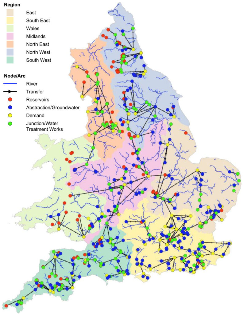
The spatial domain of the water resources supply model, WREW. Figure 2 from B. Dobson et al., The Spatial Dynamics of Droughts and Water Scarcity in England and Wales’, Water Resources Research, 56 (2020), e2020WR027187, Open Access.
The WREW model
The Water Resources of England and Wales (WREW) model has been developed through a collaboration known as the National System Simulation (NSSM) project, which is a cross-sector endeavour between the Environment Agency, DAFNI, Universities of Oxford, Bristol and Newcastle, and other partners.
The WREW model is an infrastructure system model, which can be used to provide a strategic view on national water supply infrastructure requirements. The infrastructure model lies at the bottom of a modelling chain, at the top of which sit large ensembles of climate modelling projections. A hydrological model (DECIPHeR) translates these projections of precipitation and potential evapotranspiration into river flows. The modelling chain also includes a statistical groundwater model, which estimates how much can be pumped from groundwater, which is a major source of water supply in the south-east and other parts of the country.
WREW is built in the WATHNET network flow software, which allocates available river flow, groundwater and reservoir storage to try and meet water demands and environmental needs optimally every day. WREW encodes rules, constraints and preferences that govern water infrastructure operation, with the WATHNET software not only allocating water to meet public and non-public water demands, but also trying to ensure that environmental requirements are met and respected effectively. The model allows the EA to explore what happens if inputs are varied, e.g. climate projections or level of demands, as well as what happens if the system configuration itself is changed – e.g. what if we added in a new reservoir or what if we change the capacity of a potential reservoir?
Over the past few years, WREW advances have been undertaken in three phases in the NSSM project. The first phase was proof of concept testing for testing individual SROs. The second was testing the robustness of the SROs together and exploring sensitivity under a range of climate, demand and sustainability scenarios. The latest phase has gone one step further to examine the same combinations of SROs and planning scenarios as presented in the most recent water resources management plans.
Working with DAFNI
David presented illustrative results from NSSM project phases, including examples of model performance, which illustrated how the model captures behaviour across the water resources infrastructure system. While model refinement and improvement is an ongoing process, many aspects of the model behaviour are encouraging.
“DAFNI facilitates parallelised large-scale national simulations based on 100-member (+) climate projection ensembles for the Environment Agency and enables easier collaboration with our partners and stakeholders for sharing data, results, workflows and visualisations,” enthused David. “DAFNI also enables user-friendly versioning, parameter sets, and the interfaces really bring people up to speed up with the WREW model.”
The Environment Agency has conducted a number of analyses on DAFNI over the past year, including investigations of relationships between drought characteristics and supply vulnerability across the country, assessing different climate change datasets, refining both the statistical groundwater modelling and hydrological modelling, and improving supply system representation in key areas.
David illustrated an example comparing WREW with water company modelling, involving the use of a large and complex stochastic dataset that provides many plausible realisations of climate time series. The example highlighted some of the novel visualisation approaches being developed as part of the DAFNI workflow, including a time series heat map summarising precipitation for 400 x 48-year stochastic replicates and intervals. The approach helps to identify a drought event library from the data and visualise the characteristics of each drought.
Most recently, DAFNI has helped the Environment Agency with the development of interactive visualisation tools for presenting findings to stakeholders and partners, who include academics, researchers, water companies and regulators, which model behaviour span high-level to detail-focused visualisations. Written in Python, this is a work in progress where results can be loaded